Basic Information
Observation Details
Observation Date:
December 28, 2022 - December 28, 2022Submitted:
December 28, 2022Observer:
ProZone or Region:
West Mountain AreaLocation:
West Mountain - East FacingSigns of Unstable Snow
Recent Avalanches?
None ObservedCracking?
IsolatedCollapsing?
IsolatedSnow Stability
Stability Rating:
FairConfidence in Rating:
ModerateStability Trend:
SteadyBottom Line
HST of 8" in this area is sitting on a rain crust below 7,300' that is semi-supportable. Winds were were blowing snow in all exposed areas including cross-loading off of the ridge tops, filling in the skin track every lap. I was traveling as per Moderate protocols in areas with the rain crust. I avoided steep wind-loaded areas as per Considerable protocols.
If you see anything worth noting, please submit an Observation, The PAC could use the info!
Media

Advanced Information
Weather Summary
Cloud Cover:
ObscuredTemperature:
Decreasing during the dayWind:
Strong , SWWinds were strong on the ridge tops, moderate off of the ridge tops. Variable snow rates during the day including some graupel. Generally poor visibility. Lot's of transport.
Snowpack Observations
HST of 8" sitting on a semi-supportable rain crust. Snow was damp below the crust. Interface between the crust and underlying damp snow was weak. Quick hand ECTs all were in the ECTP 1-5 range when I isolated through the crust. Pole columns indicated easy shears. On a positive note, the bond between the crust and overlaying snow is good based on hand shear tests.
The big questions is will the rain crust lock up the mid and deep snow pack until it degrades??? Perhaps for skiers, not sledders. Upper elevation areas without the crust may be a completely different scenario, i assume that i would be traveling in a Considerable mode in these zones, especially given a layer of facets that have the potential to form another PWL.
New snow was fairly dense.
Avalanche Problems
| Problem | Location | Distribution | Sensitivity | Size | Comments |
|---|---|---|---|---|---|
 Wind Slab
|
|
Layer Depth/Date: over 12" in places, could be deeper up high. Some of this is speculation, I was avoiding wind-loaded areas but observed a lot of blowing snow. I'm assuming reactive based on hand pits in one exposed area. Enough transport to require re-breaking trail in places every lap. |
|||
 Storm Slab
|
|
Storm slab outside of wind loaded areas. Stubborn due to bond with underlying crust. Not a big concern but worth mentioning. | |||
 Deep Persistent Slab
|
|
Not sure if this has been put to bed yet, I tend to worry about deep facets longer than most. I imagine that the rain crust may insulate a skier from triggering, however, I doubt the crust will support a sled. |
Terrain Use
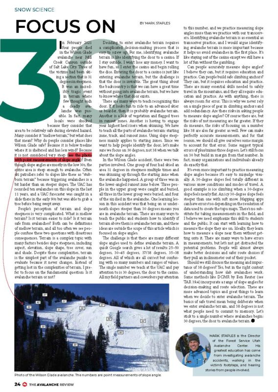
I approached from down low and avoided the wind at the ridge tops. I skied slopes/rollovers up to 35 degrees in areas with the rain crust. I avoided steep-windloaded areas. See a screen shot of a great summary of classifying slope angles within the same ski run by Mark Staples, UAC
Close